Panoramic image of Hiroshima is created from aerial photos taken by U.S. military in April 1945
Aug. 1, 2016
by Masami Nishimoto, Senior Staff Writer
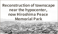
A panoramic image of the Hiroshima delta has been restored based on sharp aerial photographs taken by U.S. military forces on April 13, 1945. The image shows what the city of Hiroshima was like during the war, with rows of stores and houses under a clear sky, before it was devastated by the atomic bomb. The panoramic image was created by Yoshihiko Takesaki, 58, a specialist in geography and a resident of Naka Ward, at the request of a group tasked with compiling Hiroshima’s 70-year history since the atomic bombing, a publishing project of the city government.
Mr. Takesaki made the image of the city from five crisp photos (each one 23 by 46 centimeters) taken at an altitude of 9,754 meters. He used special geographical software to correct the tilt of the aerial photos and create an orthographic view.
Before the atomic bombing, seven rivers (now six) ran through Hiroshima, the reason it was called the “City of Water.” The clear digital image shows the townscape of Hiroshima, which was built around Hiroshima Castle.
Houses, shops, and some taller buildings are seen in and around the Nakajima district, where the Peace Memorial Park now lies. The image also shows military facilities located around the castle and other parts of the city.
Prompted by an order issued by the Japanese government at the end of 1944, some buildings were torn down as part of preparations for air raids on the city. The image also shows this work in progress. The long white part around the center of the delta between the Kyobashi River and Honkawa River indicates where buildings had been intentionally torn down to prevent fire from spreading in the event of air raids. This part of the city was eventually transformed into Peace Boulevard.
There are some aerial photos of Hiroshima taken on July 25, 1945, before the atomic bombing of Hiroshima on August 6. But the view of some areas, such as the Kasumi district in Mimami Ward, was blocked by clouds. This is the first reproduction of the full view of the Hiroshima delta prior to the atomic bombing. The aerial photos of Hiroshima are held by the U.S. National Archives.
Mr. Takesaki, whose parents experienced the atomic bombing, said, “I want those who know what Hiroshima was like before the atomic bombing to see this image, and young people to imagine what the atomic bomb did to the whole city.”
The digital image, which shows the Fuchu and Kaita areas as well as Hiroshima, can be viewed on the website of the Hiroshima Peace Media Center, a wing of the Chugoku Shimbun.
(Originally published on July 31, 2016)
A panoramic image of the Hiroshima delta