Precise geographic coordinates of hypocenter confirmed by former assistant at Hiroshima University
Oct. 12, 2020

by Masami Nishimoto, Senior Staff Writer
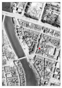
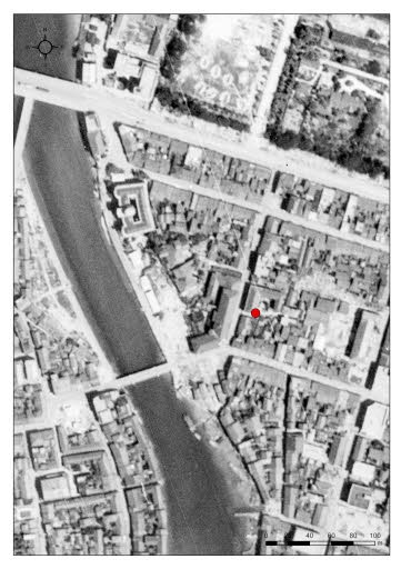
Geographic coordinates of the hypocenter at the time Hiroshima was destroyed in the atomic bombing on August 6, 1945, have been identified using the current Japanese geodetic system. The location was identified by Yoshihiko Takesaki, 62, a specialist in geography and former assistant at Hiroshima University’s Research Institute for Radiation Biology and Medicine. Mr. Takesaki utilized a geographical information system (GIS) and displayed the hypocenter location on an electronic national land map of Japan produced by the Geospatial Information Authority of Japan (GSI). Mr. Takesaki also displayed the hypocenter information on an orthographic projection of an aerial photograph taken by the U.S. military on July 25, 1945, shortly before the atomic bombing.
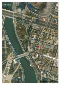
The geographic coordinates of the hypocenter are 132.454797056 degrees (132 degrees, 27 minutes, 17.3 seconds) east longitude and 34.394593542 degrees (34 degrees, 23 minutes, 40.5 seconds) north latitude. The electronic national map of Japan, based on satellite images taken in 2011, shows the hypocenter to be on the south side of the exit of a parking lot to the south of Shima Clinic, located at Otemachi 1-chome in the city’s Naka Ward. According to Dr. Kazuhide Shima, 86, honorary director of the hospital, the location is near the courtyard of the former hospital, space that is now leased as a parking lot.
Members of Japan’s Institute of Physical and Chemical Research visited Hiroshima in October 1945 and confirmed that the atomic bomb had exploded in the sky above Shima Hospital, located in what was then Saiku-machi (now Otemachi 1-chome). The coordinate values were determined based on a report compiled and released by the Atomic Bomb Casualty Commission (ABCC, now the Japan/U.S. binational Radiation Effects Research Foundation) in 1969 after American experts reexamined U.S. Army maps the same year.
Mr. Takesaki converted the coordinate values from the 1969 report, which were also used when scientists from Japan and the United States created the dosimetry system DS02 for estimating radiation doses in 2003, into the orthographic projection coordinate system, which is more precise and used for the current land map of Japan. He also showed the location using an image taken by the U.S. military before the atomic bombing that later underwent geometric tilt correction. Details of this procedure are included in the latest research report compiled by a study group that examines artifacts related to the atomic bombing and advises the Hiroshima Peace Memorial Museum about its exhibits.
Hiroshi Masaharu, a former professor at Toyo University who also served as head of the National Mapping Department of the GSI geospatial organization, said, “This is a proper method that has improved the precision of the geographic coordinates of the hypocenter. I believe that showing the location on a digital map will encourage more young people to learn about the atomic bombing.”
(Originally published on October 12, 2020)
In vicinity of former Shima Hospital courtyard
Geographic coordinates of the hypocenter at the time Hiroshima was destroyed in the atomic bombing on August 6, 1945, have been identified using the current Japanese geodetic system. The location was identified by Yoshihiko Takesaki, 62, a specialist in geography and former assistant at Hiroshima University’s Research Institute for Radiation Biology and Medicine. Mr. Takesaki utilized a geographical information system (GIS) and displayed the hypocenter location on an electronic national land map of Japan produced by the Geospatial Information Authority of Japan (GSI). Mr. Takesaki also displayed the hypocenter information on an orthographic projection of an aerial photograph taken by the U.S. military on July 25, 1945, shortly before the atomic bombing.
The geographic coordinates of the hypocenter are 132.454797056 degrees (132 degrees, 27 minutes, 17.3 seconds) east longitude and 34.394593542 degrees (34 degrees, 23 minutes, 40.5 seconds) north latitude. The electronic national map of Japan, based on satellite images taken in 2011, shows the hypocenter to be on the south side of the exit of a parking lot to the south of Shima Clinic, located at Otemachi 1-chome in the city’s Naka Ward. According to Dr. Kazuhide Shima, 86, honorary director of the hospital, the location is near the courtyard of the former hospital, space that is now leased as a parking lot.
Members of Japan’s Institute of Physical and Chemical Research visited Hiroshima in October 1945 and confirmed that the atomic bomb had exploded in the sky above Shima Hospital, located in what was then Saiku-machi (now Otemachi 1-chome). The coordinate values were determined based on a report compiled and released by the Atomic Bomb Casualty Commission (ABCC, now the Japan/U.S. binational Radiation Effects Research Foundation) in 1969 after American experts reexamined U.S. Army maps the same year.
Mr. Takesaki converted the coordinate values from the 1969 report, which were also used when scientists from Japan and the United States created the dosimetry system DS02 for estimating radiation doses in 2003, into the orthographic projection coordinate system, which is more precise and used for the current land map of Japan. He also showed the location using an image taken by the U.S. military before the atomic bombing that later underwent geometric tilt correction. Details of this procedure are included in the latest research report compiled by a study group that examines artifacts related to the atomic bombing and advises the Hiroshima Peace Memorial Museum about its exhibits.
Hiroshi Masaharu, a former professor at Toyo University who also served as head of the National Mapping Department of the GSI geospatial organization, said, “This is a proper method that has improved the precision of the geographic coordinates of the hypocenter. I believe that showing the location on a digital map will encourage more young people to learn about the atomic bombing.”
(Originally published on October 12, 2020)