3D images of Nagasaki before and after atomic bombing produced by RECNA, made publicly available on website
Nov. 20, 2022
by Kyoko Niiyama, Staff Writer
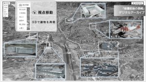
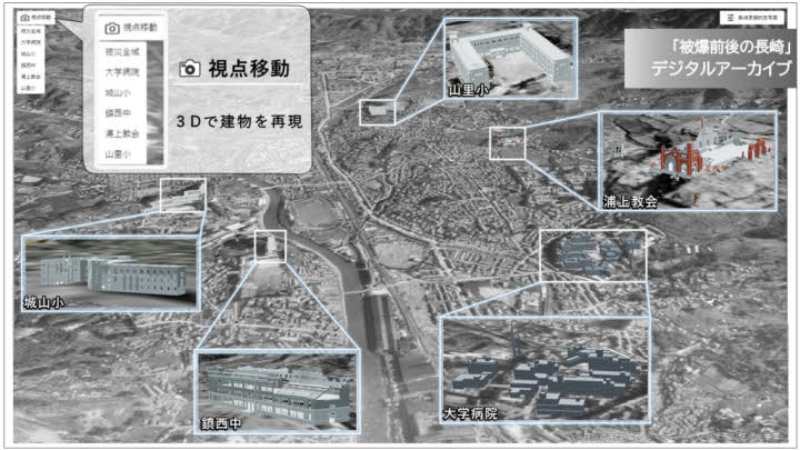
The Research Center for Nuclear Weapons Abolition (RECNA) at Nagasaki University has produced an elaborate three-dimensional, bird’s-eye image of Nagasaki City both before and after the atomic bombing, using aerial photographs taken by the U.S. military of areas around the hypocenter. The images have been made publicly available on the university’s website for A-bomb survivors sharing testimonies of their experiences in the atomic bombing to use them in illustrating the routes they took when fleeing the catastrophe or for students engaged in peace studies.
The 3D images were created by Byungdug Jun, a professor at the university’s School of Information and Data Science, among others. The university team used 29 photos in the possession of the U.S. National Archives and Records Administration. The photos were taken on August 7, 1945, two days before the atomic bombing of Nagasaki, and one month later, on September 7, “of details from all angles in an attempt to confirm the destructive power of the atomic bomb,” said Mr. Jun. The original digital data of the photos were pieced together on an online map, with corrections made for overlapping areas and tilting, to create the 3D images.
Reflecting the geographic characteristics of Nagasaki, a narrow flat piece of land extending north and south, the image of the city prior to the atomic bombing covers a diameter measuring 12–20 kilometers vertically from the hypocenter, and the image of after the bombing 5–12 kilometers. With a cursor on a computer screen, a bird’s-eye view of the scorched ruins can be generated from different angles, allowing a comparison of differences between the circumstances of the area before and after the bombing.
Six buildings, including the completely destroyed Urakami Cathedral and the Yamazato National School, where around 1,300 people were killed in the bombing, have been three-dimensionally recreated using computer graphics and positioned on the map, revealing the damage caused by the bombing. Mr. Jun is planning to call on members of the public to provide photos taken before and after the atomic bombing in an effort to reproduce more buildings from that time with computer graphics and then position those structures on the map.
This project is part of a joint effort with the Nagasaki National Peace Memorial Hall for the Atomic Bomb Victims to digitize and place materials online with the aim of passing on the reality of the atomic bombing. “The map shows the names of places and buildings that are often heard in A-bomb survivors’ testimonies. We hope the map can be utilized for learning about peace,” said Mr. Jun. To access the images: https://nagasaki-genbaku.reearth.io/
(Originally published on November 28, 2022)