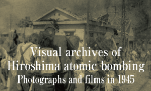
Documenting Hiroshima 80 years after A-bombing: Color photos in existence today capture activities at memorial tower, shrine one year later
Jan. 23, 2025

by Kyosuke Mizukawa, Senior Staff Writer, and Maho Yamamoto, Staff Writer
Color photographs taken in Hiroshima City between August and December 1946 by Robert Mosier show provisional shacks, a memorial stone tower, and the former site of a school that closed after the bombing, all located near the hypocenter. Looking at the photos brings into sharper relief scenes of the city from that time. The photos were taken at a time before color photography had become widely used in Japan. They represent evidence of the city’s “colors” the year after the atomic bombing.
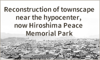
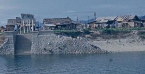
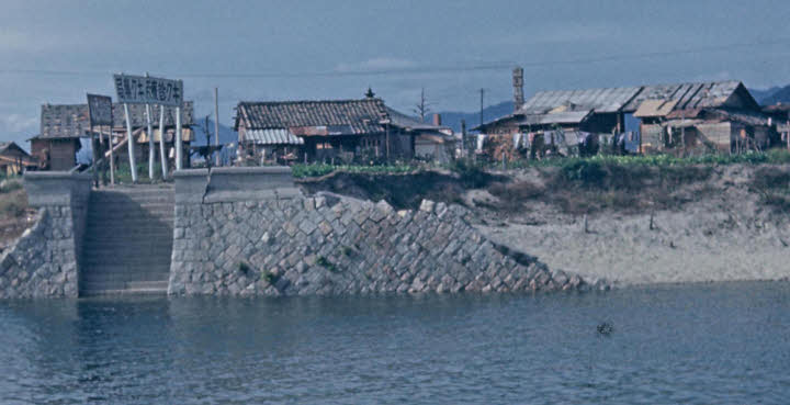
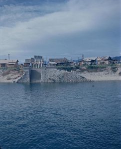
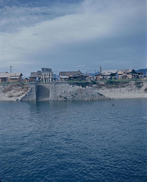
Mr. Mosier’s photos include some of the area of Nakajima-honmachi (present-day Peace Memorial Park, in Hiroshima’s Naka Ward) taken from the opposite, east bank side of Motoyasu River next to the Hiroshima Prefectural Industrial Promotion Hall (present-day A-bomb Dome, in the city’s Naka Ward). Enlarging the photos clearly reveals the upper part of a memorial stone tower (around six meters in height) for the war dead in Hiroshima, built in May 1946, located on the other side of a shack. A house of worship, which held a memorial gathering for victims on August 6, was built next to the tower.
The photos also show laundry hung in front of the shack, as well as a sign reading “Kiku Pharmacy,” a shop that existed in the area from a time before the atomic bombing. Meanwhile, the Hiroshima City government moved ahead with the idea of turning the entire area, including Nakajima-honmachi, into a park. The Chugoku Shimbun dated September 10, 1946, reported that some residents of Nakajima-honmachi and neighboring areas were opposed to “the city plan to establish a Nakajima district park,” arguing it would hinder commercial functions in the district.
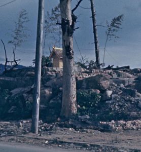
Other of Mr. Mosier’s photos, taken near the site of Shirakami-sha Shrine (in Hiroshima’s present-day Naka Ward), whose main hall had been completely destroyed and burned to the ground around 500 meters south of the hypocenter, reveal a small, newly erected building. Toshimichi Munakata, 56, chief priest of the shrine today, said, “It appears as if four Sasa bamboo trees stood there with rice-straw rope shimenawa tied around the site. I assume it was a provisional shrine building.” The shrine’s main hall was fully rebuilt in 1955, 10 years after the bombing.
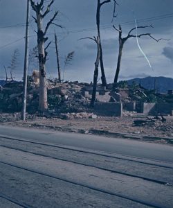
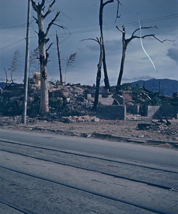
A photo of the area with reddish brown rubble was found to have been taken at the former site of the Otemachi National School (in Hiroshima’s present-day Naka Ward). The school was forced to close because of the atomic bombing. According to the Record of the Hiroshima A-bomb War Disaster, the bombing completely destroyed and burned to the ground the school’s wood building, located around 1.1 kilometers from the hypocenter, killing 35 students. A total of 181 students were missing after the bombing or unreachable. In a city showing signs of recovery, the photo represents the school’s interrupted history of education.
(Originally published on January 23, 2025)
Color photographs taken in Hiroshima City between August and December 1946 by Robert Mosier show provisional shacks, a memorial stone tower, and the former site of a school that closed after the bombing, all located near the hypocenter. Looking at the photos brings into sharper relief scenes of the city from that time. The photos were taken at a time before color photography had become widely used in Japan. They represent evidence of the city’s “colors” the year after the atomic bombing.
Mr. Mosier’s photos include some of the area of Nakajima-honmachi (present-day Peace Memorial Park, in Hiroshima’s Naka Ward) taken from the opposite, east bank side of Motoyasu River next to the Hiroshima Prefectural Industrial Promotion Hall (present-day A-bomb Dome, in the city’s Naka Ward). Enlarging the photos clearly reveals the upper part of a memorial stone tower (around six meters in height) for the war dead in Hiroshima, built in May 1946, located on the other side of a shack. A house of worship, which held a memorial gathering for victims on August 6, was built next to the tower.
The photos also show laundry hung in front of the shack, as well as a sign reading “Kiku Pharmacy,” a shop that existed in the area from a time before the atomic bombing. Meanwhile, the Hiroshima City government moved ahead with the idea of turning the entire area, including Nakajima-honmachi, into a park. The Chugoku Shimbun dated September 10, 1946, reported that some residents of Nakajima-honmachi and neighboring areas were opposed to “the city plan to establish a Nakajima district park,” arguing it would hinder commercial functions in the district.
Other of Mr. Mosier’s photos, taken near the site of Shirakami-sha Shrine (in Hiroshima’s present-day Naka Ward), whose main hall had been completely destroyed and burned to the ground around 500 meters south of the hypocenter, reveal a small, newly erected building. Toshimichi Munakata, 56, chief priest of the shrine today, said, “It appears as if four Sasa bamboo trees stood there with rice-straw rope shimenawa tied around the site. I assume it was a provisional shrine building.” The shrine’s main hall was fully rebuilt in 1955, 10 years after the bombing.
A photo of the area with reddish brown rubble was found to have been taken at the former site of the Otemachi National School (in Hiroshima’s present-day Naka Ward). The school was forced to close because of the atomic bombing. According to the Record of the Hiroshima A-bomb War Disaster, the bombing completely destroyed and burned to the ground the school’s wood building, located around 1.1 kilometers from the hypocenter, killing 35 students. A total of 181 students were missing after the bombing or unreachable. In a city showing signs of recovery, the photo represents the school’s interrupted history of education.
(Originally published on January 23, 2025)